Shrimp Line
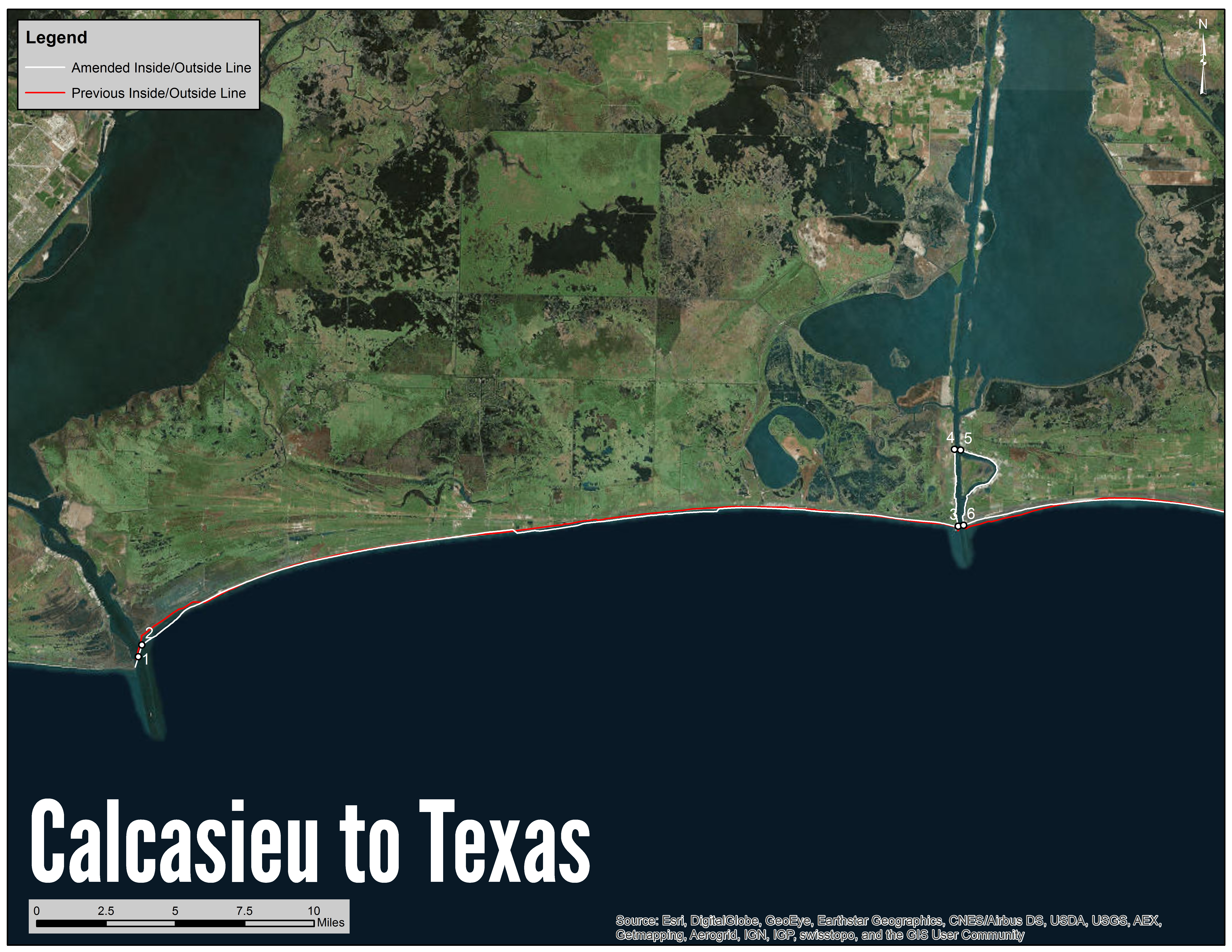
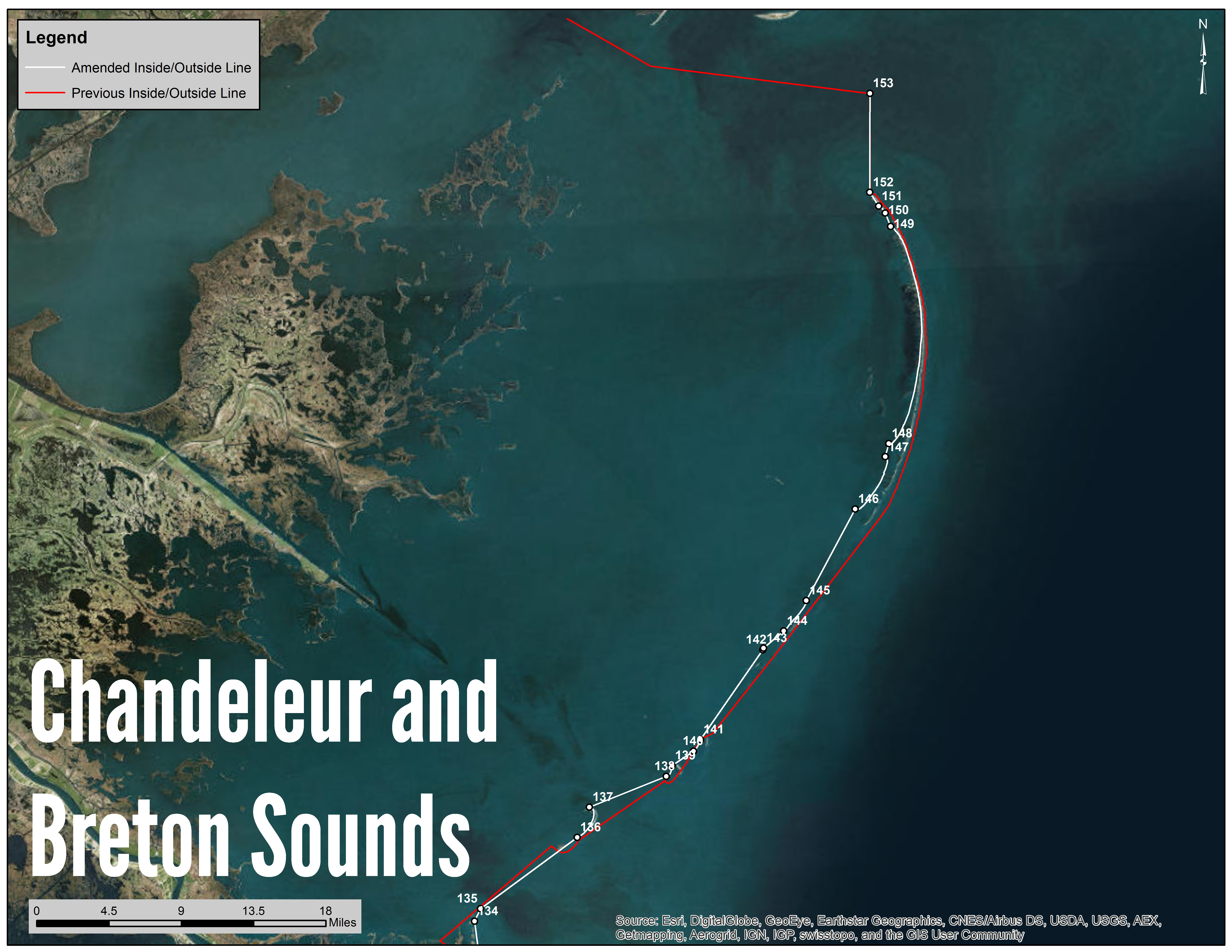
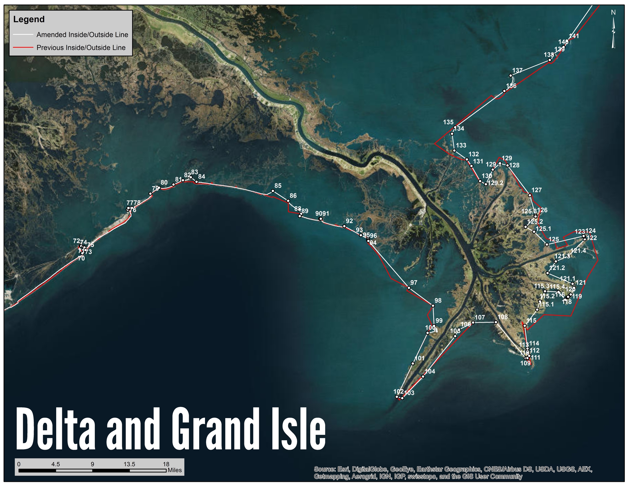
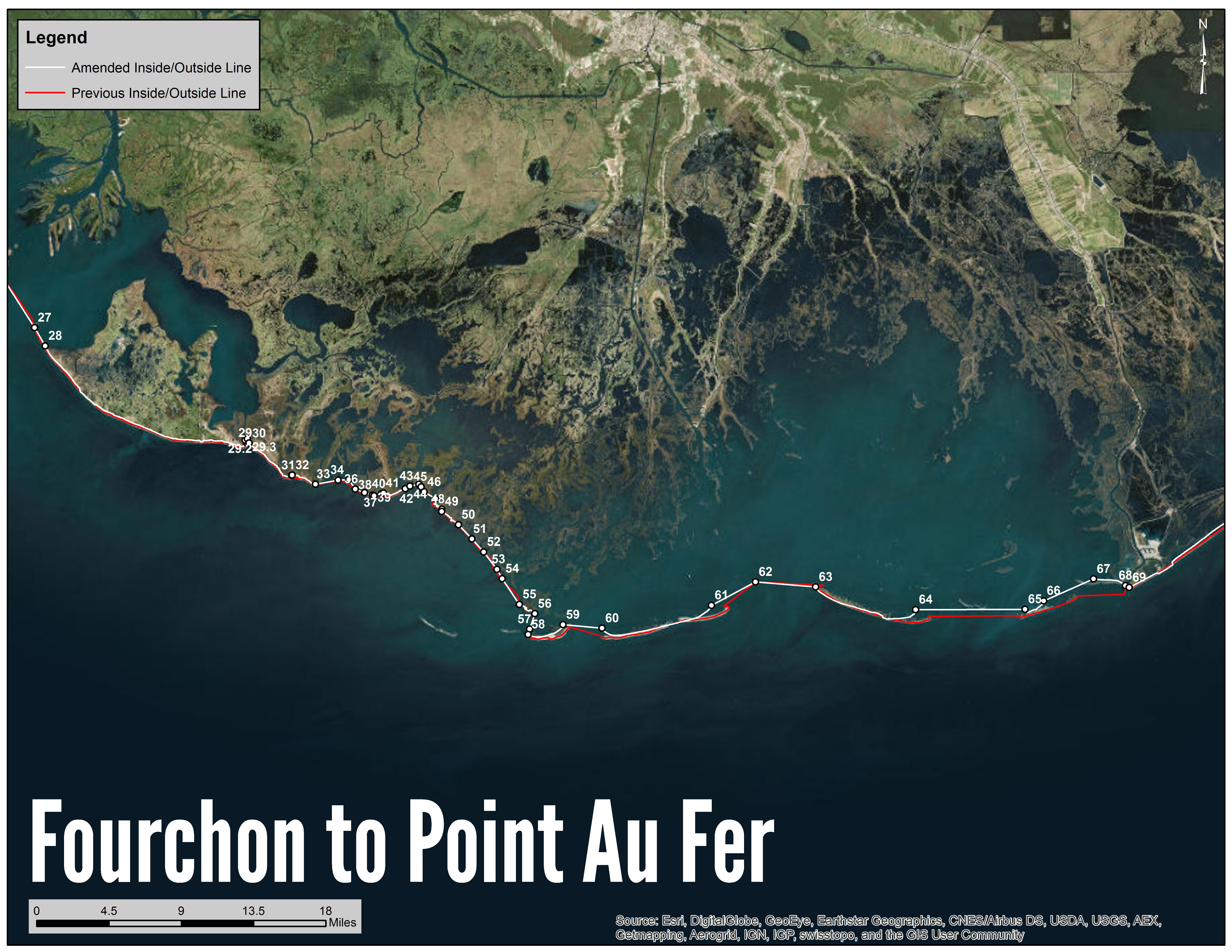
Louisiana’s state waters are divided into inside and outside waters for management purposes. The inside/outside shrimp line separates these waters. The line generally follows the coastline from the Louisiana/Texas state line to the Louisiana/Mississippi state line. Waters landward of the shrimp line are inside waters; waters seaward of the shrimp line out to the three mile line are outside waters. Inside waters are further divided into seven major estuarine basins. The Louisiana Legislature, Wildlife and Fisheries Commission, and LDWF are responsible for managing the shrimp fishery in inside and outside waters. The Gulf of Mexico Fishery Management Council and NOAA Fisheries are responsible for the shrimp fishery in federal waters.
The inside/outside shrimp line has been changed as of September 1, 2018. In March 2018, the Commission adopted a rule to amend the current line due to land loss and erosion caused by storm surge, tidal movements, and other natural causes. Approximately, 61,000 acres were added to the state's outside waters. These changes were made using 2015 satellite imagery.
Maps by Area
Calcasieu to Texas
Chandeleur and Breton Sounds
Delta and Grand Isle
Fourchon to Point Au Fer
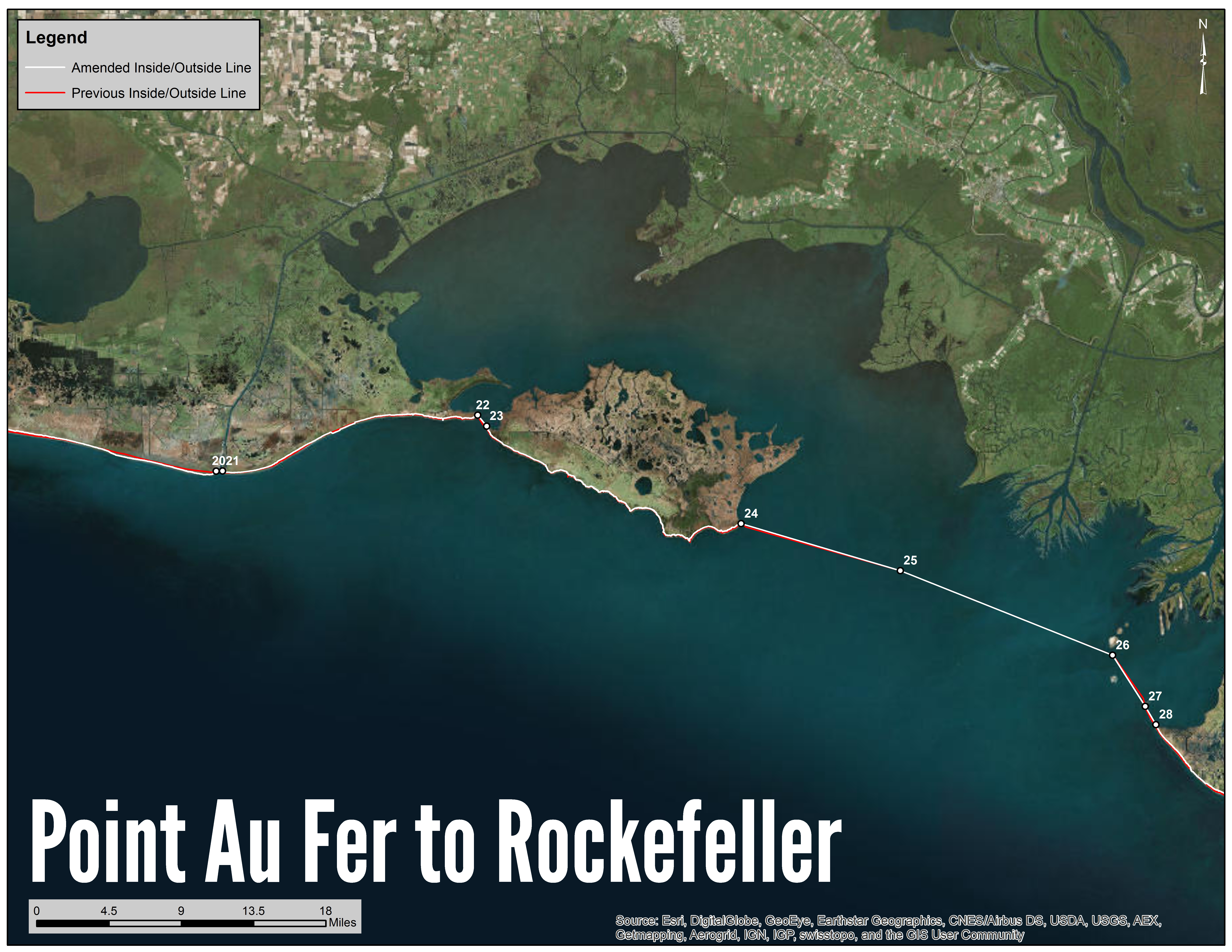
Point Au Fer to Rockefeller
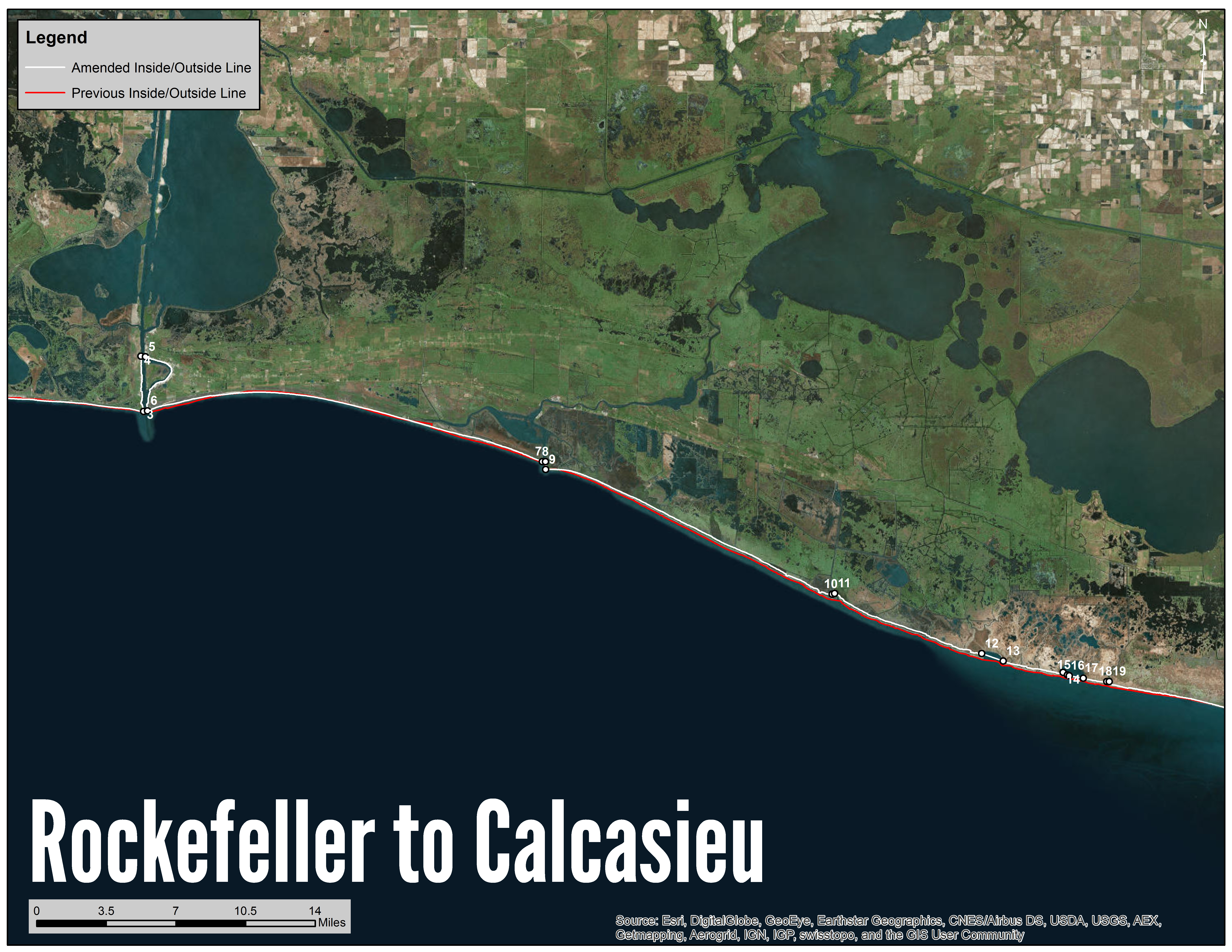
Rockefeller to Calcasieu
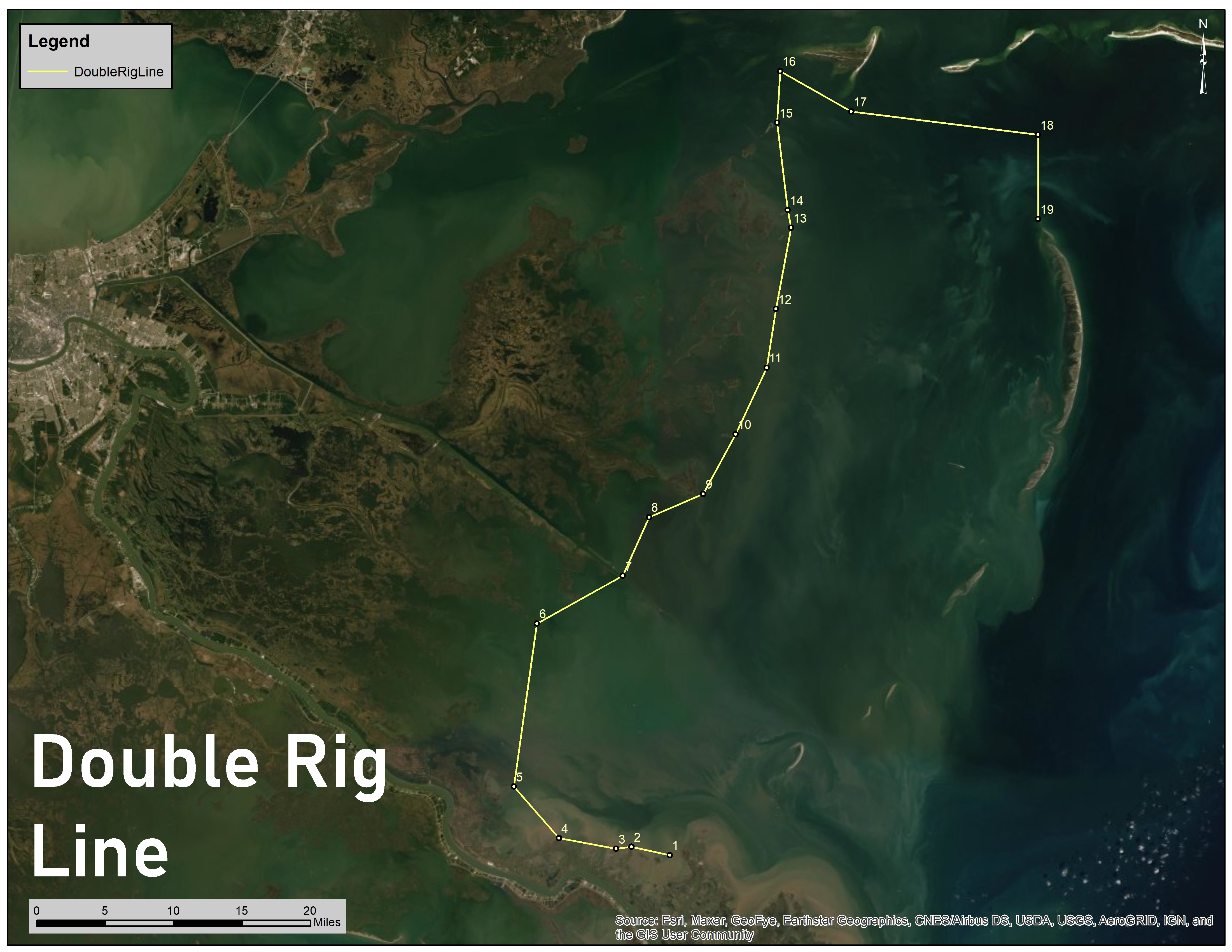
Double rig Line
GPS Coordinates
View the full list of GPS coordinates of the current shrimp line:
(1) Beginning at a point on the state line between Texas and Louisiana from "Texas Point", approximately located at latitude 29 degrees 41' 04.95120" north, longitude 93 degrees 50' 09.44039" west.
(2) Thence northeast approx. 2,344 feet to the southeast point of land of the Sabine Pass known as “Louisiana Point”, latitude 29 degrees 41' 27.25554" north, longitude 93 degrees 50' 02.11628" west.
(3) Thence in an easterly direction along the shoreline to the west point of land of Calcasieu Pass, latitude 29 degrees 45' 41.45070" north, longitude 93 degrees 20' 44.39036" west.
(4) Thence in a northerly direction along the west bank of the Calcasieu Ship Channel to a northwest point of land, latitude 29 degrees 48' 06.32085" north, longitude 93 degrees 20' 55.34353" west.
(5) Thence southeasterly approximately 1,193 feet to a northeast point of land on the east side of Calcasieu Ship Channel, latitude 29 degrees 48' 05.18206" north, longitude 93 degrees 20' 41.86770" west.
(6) Thence in a southerly direction along the east bank of the Calcasieu River to the east point of land of Calcasieu Pass, latitude 29 degrees 45' 43.19858" north, longitude 93 degrees 20' 32.62863" west.
(7) Thence in an easterly direction along the shore to the west point of land at the mouth of the Mermentau Ship Channel, latitude 29 degrees 43' 46.30700" north, longitude 93 degrees 00' 41.06756" west.
(8) Thence east approximately 832 feet to the east point of land at the mouth of the Mermentau Ship Channel, latitude 29 degrees 43' 46.29737" north, longitude 93 degrees 00' 31.63360" west.
(9) Thence in an southerly direction along the shore to the south point of land at the mouth of the Mermentau Ship Channel, latitude 29 degrees 43' 25.60948" north, longitude 93 degrees 00' 30.26638" west.
(10) Thence in an easterly direction along the shore to a point of land on the west side of Joseph Harbor Bayou, latitude 29 degrees 38' 08.37189" north, longitude 92 degrees 46' 03.00163" west.
(11) Thence northeast approximately 706 feet to a point of land on the east side of Joseph Harbor Bayou, latitude 29 degrees 38' 10.47916" north, longitude 92 degrees 45' 55.37332" west.
(12) Thence in an easterly direction along the shore to the west point of land on Big Constance Lake, latitude 29 degrees 35' 36.72869" north, longitude 92 degrees 38' 30.82610" west.
(13) Thence southeast approximately 6,026 feet to a point of land on the east side of Big Constance Lake, latitude 29 degrees 35' 17.67924" north, longitude 92 degrees 37' 26.14821" west.
(14) Thence in an easterly direction along the shore to the west point of land on Flat Lake, latitude 29 degrees 34' 49.57153" north, longitude 92 degrees 34' 25.11975" west.
(15) Thence southeast approximately 1,322 feet to the west point of land on the Island in Flat Lake, latitude 29 degrees 34' 42.88204" north, longitude 92 degrees 34' 12.25707" west.
(16) Thence in an easterly direction along the shore to the east point of land on the Island in Flat Lake, latitude 29 degrees 34' 41.14071" north, longitude 92 degrees 34' 06.44475" west.
(17) Thence in an easterly direction approximately 3,729 feet to the east point of land on Flat Lake, latitude 29 degrees 34' 35.11035" north, longitude 92 degrees 33' 24.78254" west.
(18) Thence in an easterly direction along the shore to the west point of land on Rollover Bayou, latitude 29 degrees 34' 26.98807" north, longitude 92 degrees 32' 13.49527" west.
(19) Thence east approximately 624 feet to the east point of land on Rollover Bayou, latitude 29 degrees 34' 27.05142" north, longitude 92 degrees 32' 06.42546" west.
(20) Thence in a southeasterly direction along the shore to a point of land on the west side of the mouth of Freshwater Bayou Channel, latitude 29 degrees 32' 06.16258" north, longitude 92 degrees 18' 41.19677" west.
(21) Thence east approximately 2,092 feet to a point of land on the east side of the mouth of Freshwater Bayou Channel, latitude 29 degrees 32' 06.37004" north, longitude 92 degrees 18' 17.51635" west.
(22) Thence in an easterly direction along the shore to a point of land on the west side of Southwest Pass, latitude 29 degrees 35' 14.28597" north, longitude 92 degrees 02' 29.00306" west.
(23) Thence southeast approximately 4,655 feet to Lighthouse Point, the east point of land of Southwest Pass, latitude 29 degrees 34' 38.68472" north, longitude 92 degrees 01' 55.52266" west.
(24) Thence in an easterly direction along the shore to a point of land on the southeast side of Marsh Island, known as “South Point”, latitude 29 degrees 29' 25.41005" north, longitude 91 degrees 46' 06.44233" west.
(25) Thence southeast approximately 54,641 feet to a platform in East Cote Blanche Bay known as “Double Stacks”, latitude 29 degrees 26' 53.99982" north, longitude 91 degrees 36' 13.00008" west.
(26) Thence southeast approximately 75,100 feet to the Eugene Island Lighthouse and Radio Tower, latitude 29 degrees 22' 19.63544" north, longitude 91 degrees 23' 03.82294" west.
(27) Thence in a southeasterly direction approximately 19,990 feet to the south point of land on Little Pointe Au Fer Island, latitude 29 degrees 19' 33.01214" north, longitude 91 degrees 21' 01.95819" west.
(28) Thence southeast approximately 6,928 feet to the northwest point of Point au Fer Island, latitude 29 degrees 18' 33.79644" north, longitude 91 degrees 20' 22.47380" west.
(29) Thence in an easterly direction along the shore to a point of land on the west side of Oyster Bayou, latitude 29 degrees 13' 16.94873" north, longitude 91 degrees 07' 54.47860" west.
(29.1) Thence northwesterly approximately 1,066 feet along the shoreline of Oyster Bayou to a point located at latitude 29 degrees 13' 25.9932" north, longitude 91 degrees 08' 00.582" west.
(29.2) Thence northeast across Oyster Bayou to a point on the opposite shore located at latitude 29 degrees 13' 30.5472" north, longitude 91 degrees 07' 52.2048" west.
(29.3) Thence southeast approximately 1,555 feet along the shoreline of Oyster Bayou to a point located at latitude 29 degrees 13' 16.9104" north, longitude 91 degrees 07' 46.0848" west.
(30) Thence due south across the sand deposits to a point located at the mouth of Oyster Bayou at latitude 29 degrees 13' 15.7116" north, longitude 91 degrees 07' 46.0848" west.
(31) Thence in a southeasterly direction along the shore to a point of land on the west side of Bayou Goreau, latitude 29 degrees 11' 31.23316" north, longitude 91 degrees 05' 08.55272" west.
(32) Thence northeast approximately 197 feet to a point of land on the east side of Bayou Goreau, latitude 29 degrees 11' 32.00005" north, longitude 91 degrees 05' 06.50709" west.
(33) Thence in a southeasterly direction along the shore to a point of land on the northwest side of Caillou Bay, at a pipeline canal, latitude 29 degrees 11' 02.25687" north, longitude 91 degrees 03' 39.91642" west.
(34) Thence northeast approximately 7,563 feet to the south point of Pelican Island in Terrebonne Parish, latitude 29 degrees 11' 15.46442" north, longitude 91 degrees 02' 15.93298" west.
(35) Thence northeast approximately 3,508 feet to the east point of Pelican Pass in Terrebonne Parish, latitude 29 degrees 11' 17.43943" north, longitude 91 degrees 01' 36.41672" west.
(36) Thence southeast approximately 3,845 feet to the west point of the mouth of Jack Stout Bayou, latitude 29 degrees 10' 45.91373" north, longitude 91 degrees 01' 12.11677" west.
(37) Thence southeast approximately 3,213 feet to the east point of the mouth of Jack Stout Bayou, latitude 29 degrees 10' 34.77304" north, longitude 91 degrees 00' 38.17378" west.
(38) Thence in a southeasterly direction along the shore to a point of land on the west side of the mouth of Bayou Charbon, latitude 29 degrees 10' 26.60339" north, longitude 91 degrees 00' 08.78997" west.
(39) Thence southeast approximately 603 feet to the east point of the mouth of Bayou Charbon, latitude 29 degrees 10' 24.09051" north, longitude 91 degrees 00' 02.61837" west.
(40) Thence in an easterly direction along the shore to the west point of Little Jack Stout Bayou, latitude 29 degrees 10' 30.53538" north, longitude 90 degrees 59' 35.80642" west.
(41) Thence northeast approximately 743 feet to the east point of Little Jack Stout Bayou, latitude 29 degrees 10' 33.06175" north, longitude 90 degrees 59' 27.94047" west.
(42) Thence in an easterly direction along the shore to the west point of Grand Bayou Du Large Washout, latitude 29 degrees 10' 46.71793" north, longitude 90 degrees 58' 06.59105" west.
(43) Thence northeast approximately 1,785 feet to the east point of Grand Bayou Du Large Washout, latitude 29 degrees 10' 55.66835" north, longitude 90 degrees 57' 49.23370" west.
(44) Thence northeast approximately 2,998 feet to the east point of mouth of Grand Bayou Du Large, latitude 29 degrees 11' 01.64086" north, longitude 90 degrees 57' 16.10137" west.
(45) Thence southeast approximately 1,136 feet to the south point of mouth of Fish Bayou, latitude 29 degrees 10' 52.78854" north, longitude 90 degrees 57' 08.20611" west.
(46) Thence in a southerly direction along the shore to the west point of Bayou Grand Caillou, latitude 29 degrees 10' 36.20213" north, longitude 90 degrees 56' 57.11505" west.
(47) Thence southeast approximately 4,432 feet to the east point of Bayou Grand Caillou, latitude 29 degrees 10' 14.05594" north, longitude 90 degrees 56' 13.95794" west.
(48) Thence in a southeasterly direction along the shore to the north point of the mouth of Turtle Bayou, latitude 29 degrees 09' 39.77048" north, longitude 90 degrees 55' 51.45370" west.
(49) Thence south approximately 765 feet to the south point of the mouth of Turtle Bayou, latitude 29 degrees 09' 32.21916" north, longitude 90 degrees 55' 52.04575" west.
(50) Thence in a southeasterly direction along the shore to the north point of the mouth of Bayou de l'Ouest, latitude 29 degrees 08' 49.13785" north, longitude 90 degrees 54' 50.25877" west.
(51) Thence southeast approximately 6,446 feet to the south point of the mouth of Bayou de l'Ouest, latitude 29 degrees 08' 02.57616" north, longitude 90 degrees 54' 00.55764" west.
(52) Thence southeast approximately 5,766 feet to the west point of Pass Des Ilettes, latitude 29 degrees 07' 20.21771" north, longitude 90 degrees 53' 16.98295" west.
(53) Thence southeast approximately 7,183 feet to the east point of Pass Des Ilettes, latitude 29 degrees 06' 23.54239" north, longitude 90 degrees 52' 28.08108" west.
(54) Thence southeast approximately 3,538 feet to the west point of Wilson Pass, latitude 29 degrees 05' 52.96424" north, longitude 90 degrees 52' 08.63735" west.
(55) Thence southeast approximately 10,190 feet to the east point of Wilson Pass, latitude 29 degrees 04' 28.82542" north, longitude 90 degrees 51' 05.28173" west.
(56) Thence in a southeasterly direction along the shore to the north point of Caillou Boca Pass, latitude 29 degrees 03' 58.53867" north, longitude 90 degrees 50' 08.56325" west.
(57) Thence southwesterly approximately 5,368 feet to the south point of Caillou Boca Pass, near a navigational light, latitude 29 degrees 03' 08.15855" north, longitude 90 degrees 50' 27.81820" west.
(58) Thence in a southerly direction along the shore to a point on the southwest shore of Whiskey Island, latitude 29 degrees 02' 50.74165" north, longitude 90 degrees 50' 33.50103" west.
(59) Thence in an easterly direction along the shore to the west point of Whiskey Pass, latitude 29 degrees 03' 22.40555" north, longitude 90 degrees 48' 24.25731" west.
(60) Thence east approximately 12,891 feet to the east point of Whiskey Pass, latitude 29 degrees 03' 10.14362" north, longitude 90 degrees 45' 59.69472" west.
(61) Thence in an easterly direction along the shore to the west point of Wine Island Pass, latitude 29 degrees 04' 22.79842" north, longitude 90 degrees 39' 13.91593" west.
(62) Thence northeast approximately 16,409 feet to the most easterly point of the Wine Island rock jetties, latitude 29 degrees 05' 37.99824" north, longitude 90 degrees 36' 30.00008" west.
(63) Thence southeast approximately 19,851 feet to the west point of Timbalier Island, latitude 29 degrees 05' 20.37941" north, longitude 90 degrees 32' 47.17387" west.
(64) Thence in a southeasterly direction along the shore to the west point of Little Pass Timbalier, latitude 29 degrees 04' 04.21174" north, longitude 90 degrees 26' 36.84970" west.
(65) Thence east approximately 35,929 feet to the west point of land on East Timbalier Island, latitude 29 degrees 04' 02.46147" north, longitude 90 degrees 19' 52.00898" west.
(66) Thence in an easterly direction along the shore to the west point of “Penrod Slip”, latitude 29 degrees 04' 29.18578" north, longitude 90 degrees 18' 42.55926" west.
(67) Thence northeast approximately 17,926 feet to the east point of “Penrod Slip”, latitude 29 degrees 05' 39.09466" north, longitude 90 degrees 15' 36.87269" west.
(68) Thence in an easterly direction along the shore to the west point of Belle Pass, latitude 29 degrees 05' 16.73856" north, longitude 90 degrees 13' 38.63916" west.
(69) Thence southeast approximately 1,388 feet to the east point of Belle Pass, latitude 29 degrees 05' 10.19903" north, longitude 90 degrees 13' 24.88638" west.
(70) Thence in a northeasterly direction along the shore to the southwest point of Caminada Pass, latitude 29 degrees 11' 34.92016" north, longitude 90 degrees 02' 50.94216" west.
(71) Thence in a northerly direction along the northwesterly shoreline of Caminada Pass to the intersection of an underground power line as marked by two platforms in Caminada Pass, which is the northwest point of Caminada Pass, latitude 29 degrees 12' 22.50230" north, longitude 90 degrees 03' 02.70045" west.
(72) Thence southeast along the underground power line as marked by two platforms in Caminada Pass, approximately 358 feet to the West Power Line Marker of the Caminada Channel, latitude 29 degrees 12' 21.20418" north, longitude 90 degrees 02' 58.93637" west.
(73) Thence southeast along the underground power line as marked by two platforms in Caminada Pass, approximately 1,478 feet to the East Power Line Marker of the Caminada Channel, latitude 29 degrees 12' 15.85401" north, longitude 90 degrees 02' 43.41687" west.
(74) Thence southeast approximately 781 feet to the northeast point of Caminada Pass on the northwesterly shoreline of Grand Isle, latitude 29 degrees 12' 12.25221" north, longitude 90 degrees 02' 35.65270" west.
(75) Thence in a southerly direction along the shore to the southeast point of Caminada Pass, latitude 29 degrees 11' 55.73980" north, longitude 90 degrees 02' 28.00430" west.
(76) Thence in a northeasterly direction along the south shoreline of Grand Isle to the most northerly point of Grand Isle, the west point of Barataria Pass, latitude 29 degrees 16' 10.92696" north, longitude 89 degrees 57' 17.70348" west.
(77) Thence northeasterly approximately 1,098 feet to the navigation marker known as the “Green Turn Buoy” in Barataria Pass, latitude 29 degrees 16' 20.98086" north, longitude 89 degrees 57' 12.98009" west.
(78) Thence easterly approximately 2,411 feet to the east point of Barataria Pass, at Fort Livingston ruins, latitude 29 degrees 16' 21.17236" north, longitude 89 degrees 56' 45.75555" west.
(79) Thence in a northeasterly direction along the south shoreline of Grand Terre Island to a point of land most northerly, the west point of Pass Abel, latitude 29 degrees 17' 50.66661" north, longitude 89 degrees 54' 30.79631" west.
(80) Thence northeast approximately 6,861 feet to the east point of Pass Abel, latitude 29 degrees 18' 28.77024" north, longitude 89 degrees 53' 26.65497" west.
(81) Thence in an easterly direction along the shore to the west point of Quatre Bayou Pass, latitude 29 degrees 18' 47.29679" north, longitude 89 degrees 51' 41.26373" west.
(82) Thence northeast approximately 6,697 feet to the east point of Quatre Bayou Pass, latitude 29 degrees 19' 13.89235" north, longitude 89 degrees 50' 31.97201" west.
(83) Thence in a northeasterly direction along the shore to the west point of the washout below Bay Long, latitude 29 degrees 19' 32.29984" north, longitude 89 degrees 49' 34.23242" west.
(84) Thence southeast approximately 4,682 feet to the east point of the washout below Bay Long, latitude 29 degrees 19' 03.24021" north, longitude 89 degrees 48' 53.02463" west.
(85) Thence in an easterly direction along the shore to the west point of the washout below Shell Island Bay, latitude 29 degrees 17' 57.91497" north, longitude 89 degrees 39' 37.87864" west.
(86) Thence southeast approximately 11,734 feet to the east point of the washout below Shell Island Bay, latitude 29 degrees 16' 53.15017" north, longitude 89 degrees 37' 47.86759" west.
(87) Thence in a southeasterly direction along the shore to the southeast point of Lanaux Island, latitude 29 degrees 15' 55.96639" north, longitude 89 degrees 36' 28.97569" west.
(88) Thence southeast approximately 3,044 feet to the northwest point of Pelican Island, in Plaquemines Parish, latitude 29 degrees 15' 28.50701" north, longitude 89 degrees 36' 14.82716" west.
(89) Thence in a southwesterly direction along the shore to the southwest point of Pelican Island, in Plaquemines Parish, latitude 29 degrees 15' 14.14710" north, longitude 89 degrees 36' 24.53604" west.
(90) Thence in an easterly direction along the shore to the west point of the pass of Scofield Bayou, latitude 29 degrees 14' 55.60396" north, longitude 89 degrees 33' 56.70645" west.
(91) Thence east approximately 435 feet to the east point of the pass of Scofield Bayou, latitude 29 degrees 14' 55.53846" north, longitude 89 degrees 33' 51.79374" west.
(92) Thence in a southeasterly direction along the shore to the west point of the washout below Bay Coquette, latitude 29 degrees 14' 05.57842" north, longitude 89 degrees 31' 01.38761" west.
(93) Thence southeast approximately 12,157 feet to the south point of the Sandy Point Island, latitude 29 degrees 13' 06.36125" north, longitude 89 degrees 29' 01.94537" west.
(94) Thence southeast approximately 5,134 feet to the north point of Red Pass, latitude 29 degrees 12' 43.23994" north, longitude 89 degrees 28' 10.35788" west.
(95) Thence south approximately 954 feet to the south point of Red Pass, latitude 29 degrees 12' 33.80160" north, longitude 89 degrees 28' 10.69614" west.
(96) Thence in a southeasterly direction along the shore to the southwest point of land south of Red Pass, latitude 29 degrees 12' 29.20037" north, longitude 89 degrees 28' 07.76965" west.
(97) Thence approximately 37,800 feet in a southeasterly direction to the radio tower located at latitude 29 degrees 07' 55" north, longitude 89 degrees 23' 18" west.
(98) Thence approximately 21,300 feet in a southeasterly direction to a manifold platform in the east side of Grand Pass at latitude 29 degrees 05' 28" north, longitude 89 degrees 20' 26" west.
(99) Thence approximately 12,981 feet south to the southwestern point on southern shore of Scott Bay, latitude 29 degrees 03' 19.55590" north, longitude 89 degrees 20' 20.91769" west.
(100) Thence in a southeasterly direction along the shore to the northwestern point of the mouth of Outlet W-2, latitude 29 degrees 02' 35.29280" north, longitude 89 degrees 21' 08.95367" west.
(101) Thence approximately 21,926 feet in a southwesterly direction to latitude 28 degrees 59' 20.865" north, longitude 89 degrees 22' 59.314" west.
(102) Thence approximately 45,797 feet in a southwesterly direction to a point on the west bank of Southwest Pass, latitude 28 degrees 55' 50" north, longitude 89 degrees 25' 00" west.
(103) Thence approximately 3,631 feet in a southeasterly direction to a point on the east jetty of Southwest Pass, latitude 28 degrees 55' 40.90119" north, longitude 89 degrees 24' 20.47101" west.
(104) Thence northeast approximately 19,313 feet to the south point of Burrwood Bayou, latitude 28 degrees 57' 56.42504" north, longitude 89 degrees 21' 47.16227" west.
(105) Thence northeast approximately 33,352 feet to a point on the western shore of East Bay, latitude 29 degrees 02' 11.57932" north, longitude 89 degrees 17' 48.81506" west.
(106) Thence northeast approximately 4,862 feet to Cockler Point on the western shore of East Bay, latitude 29 degrees 02' 52.70522" north, longitude 89 degrees 17' 20.35614" west.
(107) Thence northeast approximately 10,163 feet to the mouth of Joseph Bayou, latitude 29 degrees 03' 36" north, longitude 89 degrees 15' 37" west.
(108) Thence east approximately 14,733 feet to a point of land on the west bank of South Pass in Whale Bay, latitude 29 degrees 03' 36" north, longitude 89 degrees 12' 51" west.
(109) Thence in a southeasterly direction to the southeast point of the eastern shore of East Bay, latitude 28 degrees 59' 42.10926" north, longitude 89 degrees 09' 19.74294" west.
(110) Thence east approximately 1,152 feet to the south point of the west levee of South Pass, latitude 28 degrees 59' 43.04560" north, longitude 89 degrees 09' 06.81181" west.
(111) Thence in a northeasterly direction along the shore to the west point of South Pass, latitude 28 degrees 59' 56.51565" north, longitude 89 degrees 08' 53.80725" west.
(112) Thence northwest approximately 2,299 feet to the south point of the east barrier island of South Pass, latitude 29 degrees 00' 17.79651" north, longitude 89 degrees 09' 02.97217" west.
(113) Thence in a northeasterly direction along the shore to a point on the south side of the east outlet of South Pass, latitude 29 degrees 00' 34.18822" north, longitude 89 degrees 09' 05.18348" west.
(114) Thence north approximately 900 feet to the east point of the east levee of South Pass, latitude 29 degrees 00' 43.09785" north, longitude 89 degrees 09' 05.00480" west.
(115) Thence northwest approximately 14,882 feet to the southeastern point of an island southeast of the mouth of Dennis Pass, latitude 29 degrees 03' 09.64678" north, longitude 89 degrees 09' 22.20009" west.
(115.1) Thence northeasterly approximately 13,189 feet to mouth of Johnson Pass, latitude 29 degrees 04' 51.333" north, longitude 89 degrees 07' 48.981" west.
(115.2) Thence northeasterly approximately 5,530 feet to the northern bank of Cognevich Pass, latitude 29 degrees 05' 42.9432" north, longitude 89 degrees 07' 28.2036" west.
(115.3) Thence northeasterly approximately 7,345 feet to the eastern shore of the island located between North Shore Bay and Redfish Bay at latitude 29 degrees 06' 47.3508" north, longitude 89 degrees 06' 49.77" west.
(115.4) Thence East approximately 8,755 feet to the western bank of Southeast Pass seaward side in Redfish Bay, latitude 29 degrees 06' 41.562" north, longitude 89 degrees 05' 11.292" west.
(116) Thence southeasterly approximately 6,621 feet to the southwest point of the west levee of Southeast Pass, latitude 29 degrees 05' 50.61189" north, longitude 89 degrees 04' 24.33261" west.
(117) Thence in a northeasterly direction along the shore to the west point of Southeast Pass, latitude 29 degrees 06' 06.60266" north, longitude 89 degrees 04' 07.22646" west.
(118) Thence northeast approximately 535 feet to the east point of Southeast Pass, latitude 29 degrees 06' 09.42871" north, longitude 89 degrees 04' 02.12414" west.
(119) Thence in a northeasterly direction along the shore to the east point of the south levee of Micale Bayou, latitude 29 degrees 06' 21.10356" north, longitude 89 degrees 03' 46.47144" west.
(120) Thence northeast approximately 417 feet to the east point of the north levee of Micale Bayou, latitude 29 degrees 06' 23.71630" north, longitude 89 degrees 03' 42.83758" west.
(121) Thence in a northeasterly direction along the shore to the eastern-most point of land between the Southeast Pass and Northeast Pass, latitude 29 degrees 07' 05.75774" north, longitude 89 degrees 03' 17.81742" west.
(121.1) Thence northwesterly approximately 2,731 feet to the North bank of Northeast Pass, latitude 29 degrees 07' 31.2708" north, longitude 89 degrees 03' 28.0008" west.
(121.2) Thence northwesterly approximately 17,591 feet to the mouth of the Bayou just north of the Pipeline Canal that cuts through Jackass Bay to a point on the east side of the island located at latitude 29 degrees 08' 43.2276" north, longitude 89 degrees 06' 28.6272" west.
(121.3) Thence northeasterly approximately 9,262 feet to the southern bank of Jackson Bayou located at latitude 29 degrees 09' 56.934" north, longitude 89 degrees 05' 26.4948" west.
(121.4) Thence northeasterly approximately 9,034 feet to the southern bank of the island located at the mouth of Straight Bayou at latitude 29 degrees 10' 30.8424" north, longitude 89 degrees 03' 52.2036" west.
(122) Thence northeasterly approximately 14,852 feet to the east point of the south levee of North Pass, latitude 29 degrees 12' 13.91839" north, longitude 89 degrees 01' 52.71454" west.
(123) Thence northwest approximately 1,721 feet to the east point of the north levee of North Pass, latitude 29 degrees 12' 30.51489" north, longitude 89 degrees 01' 57.09847" west.
(124) Thence in a northwesterly direction along the shore to the north point of the north levee of North Pass, latitude 29 degrees 12' 35.55832" north, longitude 89 degrees 02' 00.61988" west.
(125) Thence southwest approximately 24,349 feet to the northeast point of land in Customhouse Bay, latitude 29 degrees 11' 45.47006" north, longitude 89 degrees 06' 29.35285" west.
(125.1) Thence northwesterly approximately 11,715 feet to a point located in Bucket Bend at latitude 29 degrees 13' 09.1848" north, longitude 89 degrees 08' 00.8448" west.
(125.2) Thence northwesterly approximately 6,283 feet to a point located in the southern part of Dead Women Bend near the exit location of Twentyseven Pass at latitude 29 degrees 13' 41.0736" north, longitude 89 degrees 09' 01.728" west.
(125.3) Thence northeasterly approximately 9,300 feet to a point located at the southern bank of Dead Woman Pass at latitude 29 degrees 14' 46.2984" north, longitude 89 degrees 07' 47.6472" west.
(126) Thence northwesterly approximately 752 feet to the north bank of Dead Woman Pass, latitude 29 degrees 14' 53.7252" north, longitude 89 degrees 07' 48.2736" west.
(127) Thence northwesterly approximately 13,460 feet to the northeast point of Timber Island by Bienvenue Pass, latitude 29 degrees 17' 02.66053" north, longitude 89 degrees 08' 26.62523" west.
(128) Thence northwest approximately 24,047 feet to the northeast point of the island in the mouth of Main Pass, latitude 29 degrees 20' 15.94786" north, longitude 89 degrees 11' 05.17729" west.
(129) Thence northwest approximately 5,018 feet to the north point of the west levee of Main Pass, latitude 29 degrees 20' 29.98190" north, longitude 89 degrees 11' 59.55914" west.
(129.1) Thence southwest approximately 6,155 feet to a point located just seaward from Octave Pass North at latitude 29 degrees 19' 50.9988" north, longitude 89 degrees 12' 52.9992" west.
(129.2) Thence southwest approximately 10,461 feet to a point located between Bernies Pass and Battery Bayou at latitude 29 degrees 18' 18" north, longitude 89 degrees 13' 45.0012" west.
(130) Thence northwest approximately 4,285 feet to the north point of the east levee of East Fork, latitude 29 degrees 18' 38.94519" north, longitude 89 degrees 14' 27.08895" west.
(131) Thence northwest approximately 11,244 feet to the northeast point of the east levee of the east outlet of Emeline Pass, latitude 29 degrees 20' 16.49226" north, longitude 89 degrees 15' 28.27037" west.
(132) Thence northwest approximately 5,141 feet to the northeast point of the east levee of Emeline Pass, latitude 29 degrees 20' 58.88195" north, longitude 89 degrees 16' 00.41227" west.
(133) Thence northwest approximately 9,960 feet to the southeastern point on the eastern shore of the Main Pass east levee, latitude 29 degrees 21' 57.19326" north, longitude 89 degrees 17' 31.17691" west.
(134) Thence northerly approximately 10,939 feet to an east point on the eastern shore of the Main Pass east levee, latitude 29 degrees 23' 44.78937" north, longitude 89 degrees 17' 45.23755" west.
(135) Thence northeast approximately 4,585 feet to the northeastern point on the eastern shore of the Main Pass east levee, latitude 29 degrees 24' 25.32960" north, longitude 89 degrees 17' 21.93072" west.
(136) Thence northeast approximately 39,510 feet to the south point of Breton Island, latitude 29 degrees 28' 11.81256" north, longitude 89 degrees 11' 17.62330" west.
(137) Thence in a northeasterly direction along the shore to the north point of Breton Island, latitude 29 degrees 29' 49.50414" north, longitude 89 degrees 10' 30.33595" west.
(138) Thence northeast approximately 27,234 feet to the south point of the south island of the Gosier Islands, latitude 29 degrees 31' 24.79774" north, longitude 89 degrees 05' 42.00863" west.
(139) Thence in a northeasterly direction along the shore to the north point of the south island of the Gosier Islands, latitude 29 degrees 31' 59.74482" north, longitude 89 degrees 05' 19.86319" west.
(140) Thence northeast approximately 8,509 feet to the south point of the north island of the Gosier Islands, latitude 29 degrees 32' 45.13752" north, longitude 89 degrees 03' 58.70949" west.
(141) Thence in a northeasterly direction along the shore to the north point of the north island of the Gosier Islands, latitude 29 degrees 33' 22.48000" north, longitude 89 degrees 03' 32.21823" west.
(142) Thence northeast approximately 35,924 feet to the south point of the Curlew Islands, latitude 29 degrees 38' 10.35706" north, longitude 88 degrees 59' 33.29121" west.
(143) Thence in a northeasterly direction along the shore to the north point of the Curlew Islands, latitude 29 degrees 38' 15.78007" north, longitude 88 degrees 59' 30.59398" west.
(144) Thence northeast approximately 8,761 feet to the south point of the Stake Islands, latitude 29 degrees 39' 10.60431" north, longitude 88 degrees 58' 13.65731" west.
(145) Thence in a northeasterly direction along the shore to the north point of the Stake Islands, latitude 29 degrees 40' 47.88908" north, longitude 88 degrees 56' 47.18591" west.
(146) Thence northeast approximately 34,091 feet to the south point of the south island of the Chandeleur Islands, latitude 29 degrees 45' 42.31016" north, longitude 88 degrees 53' 38.18264" west.
(147) Thence in a northeasterly direction along the shore to the north point of the south island of the Chandeleur Islands, latitude 29 degrees 48' 30.73219" north, longitude 88 degrees 51' 41.66097" west.
(148) Thence northeast approximately 4,487 feet to the south point of the main island of the Chandeleur Islands, latitude 29 degrees 49' 13.34094" north, longitude 88 degrees 51' 27.25032" west.
(149) Thence in a northerly direction along the shore to the north point of the main island of the Chandeleur Islands, latitude 30 degrees 00' 59.54256" north, longitude 88 degrees 51' 02.96200" west.
(150) Thence northwest approximately 4,782 feet to the south point of the north island of the Chandeleur Islands, latitude 30 degrees 01' 43.94624" north, longitude 88 degrees 51' 21.82982" west.
(151) Thence in a northwesterly direction along the shore to the north point of the north island of the Chandeleur Islands, latitude 30 degrees 02' 06.44260" north, longitude 88 degrees 51' 45.77415" west.
(152) Thence northwest approximately 5,401 feet to a point located at latitude 30 degrees 02' 51.98110" north, longitude 88 degrees 52' 17.98216" west; the location of the destroyed Chandeleur Light.
(153) Thence in a northerly direction to the intersection of the Louisiana-Mississippi Boundary, latitude 30 degrees 08' 14.51336" north, longitude 88 degrees 52' 09.61702" west (coordinates not specified Repealed by Acts 1991, No. 946, §2.).
View the full list of GPS coordinates of the current double rig line:
1) Beginning at the most northerly point on the south side of Taylor Pass, latitude 29 degrees 22 minutes 50.4 seconds north, longitude 89 degrees 20 minutes 3.8 seconds west, which is on the inside-outside shrimp line as described in R.S. 56:495.
2) Thence westerly to Deep Water Point, latitude 29 degrees 23 minutes 24.7 seconds north, longitude 89 degrees 22 minutes 49.8 seconds west.
3) Thence westerly to Coquille Point, latitude 29 degrees 23 minutes 18.0 seconds north, longitude 89 degrees 23 minutes 57.7 seconds west.
4) Thence westerly to Raccoon Point, latitude 29 degrees 24 minutes 02.3 seconds north, longitude 89 degrees 28 minutes 05.7 seconds west.
5) Thence northwesterly to California Point, latitude 29 degrees 27 minutes 21.7 seconds north, longitude 89 degrees 31 minutes 19.7 seconds west.
6) Thence northerly to Mozambique Point, latitude 29 degrees 37 minutes 43.4 seconds north, longitude 89 degrees 29 minutes 27.4 seconds west.
7) Thence northeasterly to Grace Point (red light no. 62 on the MRGO), latitude 29 degrees 40 minutes 40.5 seconds north, longitude 89 degrees 23 minutes 08.0 seconds west.
8) Thence northerly to Deadman Point, latitude 29 degrees 44 minutes 23.0 seconds north, longitude 89 degrees 21 minutes 09.0 seconds west.
9) Thence easterly to Point Lydia, latitude 29 degrees 45 minutes 48.0 seconds north, longitude 89 degrees 17 minutes 10.0 seconds west.
10) Thence northerly to Point Comfort, latitude 29 degrees 49 minutes 33.7 seconds north, longitude 89 degrees 14 minutes 42.7 seconds west.
11) Thence northerly to the most easterly point of Mitchell Island, latitude 29 degrees 53 minutes 46.0 seconds north, longitude 89 degrees 12 minutes 22.0 seconds west.
12) Thence northerly to the most easterly point on Martin Island, latitude 29 degrees 57 minutes 29.6 seconds north, longitude 89 degrees 11 minutes 36.6 seconds west.
13) Thence northerly to the most easterly point on Brush Island, latitude 30 degrees 02 minutes 38.6 seconds north, longitude 89 degrees 10 minutes 23.6 seconds west.
14) Thence northerly to Door Point, latitude 30 degrees 03 minutes 46.0 seconds north, longitude 89 degrees 10 minutes 36.0 seconds west.
15) Thence northerly to the most easterly point on Isle Au Pitre, latitude 30 degrees 09 minutes 20.5 seconds north, longitude 89 degrees 11 minutes 15.5 seconds west.
16) Thence north 03 degrees 20 minutes 13 seconds east (grid) a distance of 20001.25 feet (grid) to a point on the Louisiana-Mississippi Lateral Boundary, latitude 30 degrees 12 minutes 37.9056 seconds north, longitude 89 degrees 10 minutes 57.9725 seconds west.
17) Thence south 60 degrees 20 minutes 06 seconds east (grid) along the Louisiana-Mississippi Lateral Boundary a distance of 31555.93 feet (grid), latitude 30 degrees 09 minutes 58.1371 seconds north, longitude 89 degrees 05 minutes 48.9910 seconds west.
18) Thence south 82 degrees 53 minutes 54 seconds east (grid) continuing along the Louisiana-Mississippi Lateral Boundary a distance of 72650.64 feet, latitude 30 degrees 08 minutes 14.6070 seconds north, longitude 88 degrees 52 minutes 10.0766 seconds west.
19) Thence south 0 degrees 03 minutes 38 seconds west (grid) a distance of 32493.40 feet (grid) to the Chandeleur Light, latitude 30 degrees 02 minutes 53.0312 seconds north, longitude 88 degrees 52 minutes 18.4173 seconds west, which is on the inside-outside shrimp line as described in R.S. 56:495.
20) Thence southerly along the inside-outside shrimp line as described in R.S. 56:495 to the point of beginning.
Download GPS coordinates of the current shrimp line:
Download GPS coordinates for interactive map use:
Download GPS coordinates of the double rig line:
To access the menhaden buffer zone maps and files (which are relative to the inside/outside line) click the button below.