 Official Louisiana State Websites use .la.gov
  Secure .gov websites use HTTPS
White Lake Wetlands Conservation Area
Located in southwestern Louisiana, White Lake Wetlands Conservation Area was owned and managed by various oil companies until BP donated the property to the state of Louisiana in 2002.
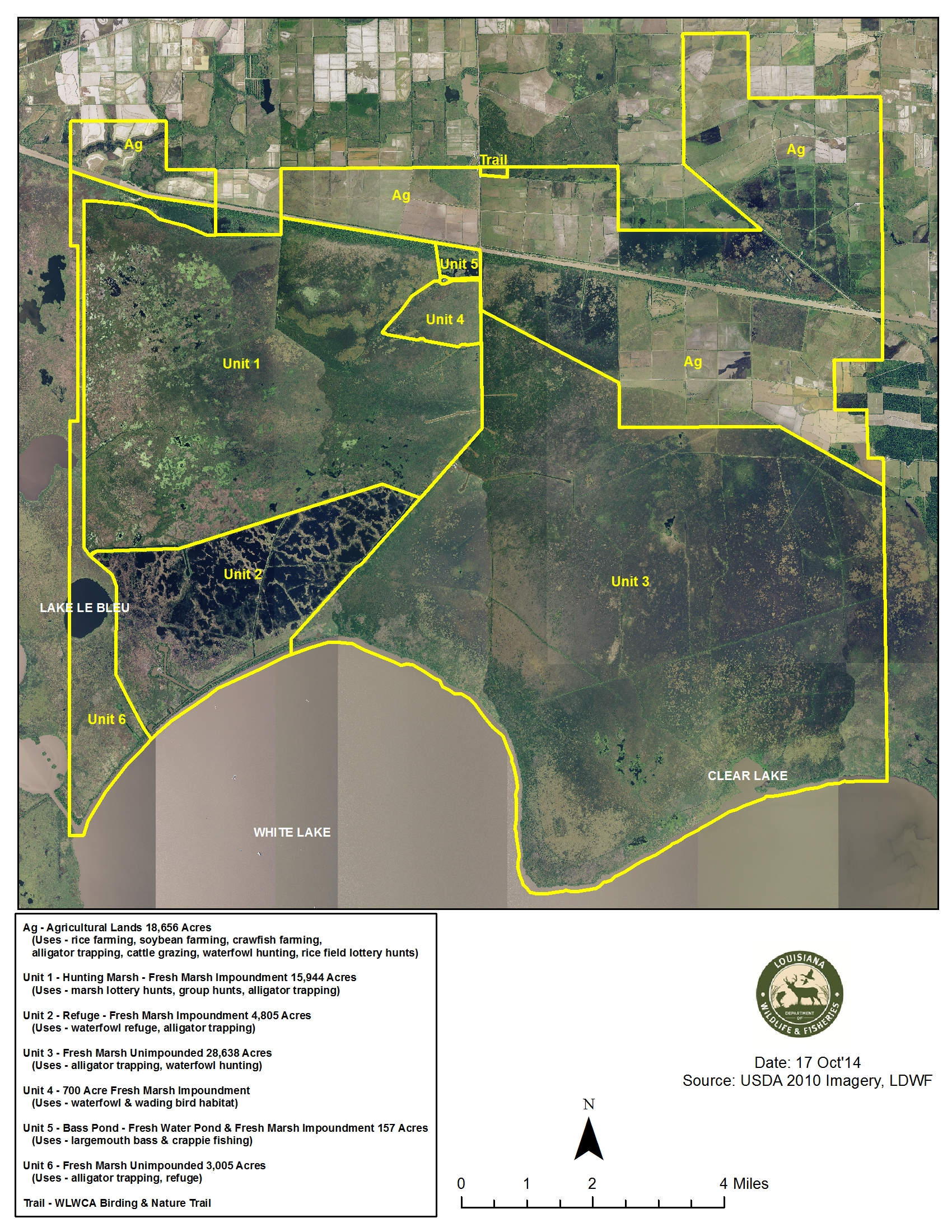
About 75% of White Lake is freshwater marsh; the remainder is leased property that contains a combination of cropland, wetlands, wooded areas, and campsites. The freshwater marsh areas are dominated by maidencane, bull tongue, cattail, Jamaican sawgrass, roseau cane, spikerush, Walter’s millet, and buttonbush, in addition to numerous species of submerged aquatic vegetation.
For more information,
contact Lance Ardoin at
LArdoin@wlf.la.gov or
337-536-6061
Many brush and tree species are found on the numerous levees and high ground throughout the area. The habitat is very diverse on the leased property - it includes cropland planted in rice, soybean, or millet, freshwater marsh impoundments, densely wooded areas, grass pastures, and freshwater ponds.
LDWF manages the freshwater marsh to produce high quality habitat for waterfowl, shorebirds, alligators, and numerous other species through:
- Producing favorable conditions for waterfowl and shorebird habitat and forage growth
- Producing adequate resting/loafing areas and limiting hunting pressure
- Maintaining interspersed open ponds with surrounding emergent vegetation
- Maintaining habitat for nesting and brood rearing of coastal nesting species
- Restoring and maintaining habitat for alligator nesting
- Preserving wading bird rookery sites
- Maintaining trails through the marsh to provide fish habitat and encourage dispersion
- Reducing nuisance aquatic vegetation.
LDWF manages the agricultural property on White Lake to maintain all of the cropland in farmable condition and maintain rice production. LDWF also enhances habitat in this area for wintering waterfowl.
White Lake is a self-sustaining property; it operates without any state tax dollars. Revenue is generated on the property through alligator and alligator egg harvest, lottery waterfowl hunts, lottery fishing permits, events, and leases for agriculture, hunting, fishing, and other surface uses. BP Amoco maintains mineral rights for the entire property, so the property does not receive any funding from oil and gas production, exploration, or mineral leases.
All visitors must have a WMA Access Permit and comply with self-clearing permit guidelines.
White Lake Conservation Area Gallery
Conservation Area Details
Acreage
71,905 acres
Parish
Vermilion Parish
Owner/Manager
LDWF
Activities and Amenities
Hunting
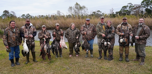
White Lake offers excellent waterfowl hunting. Hunt participants are selected by lottery; lottery hunts include teal, youth, marsh, and rice field.
Fishing and Boating
LDWF distributes 100 fishing/boating permits by lottery for Florence Canal and associated oil field location canals on White Lake Wetlands Conservation Area each year. Common fish include blue catfish, largemouth bass, and crappie (sac-a-lait).
Birding and Wildlife Viewing
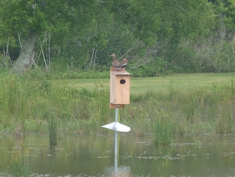
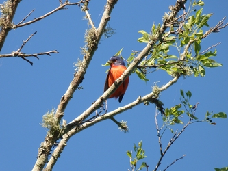
Visitors can expect to see a variety of plants, mammals, reptiles, and resident and migratory birds including waterfowl, wading birds, and songbirds. In fact, 174 species of birds have been documented on White Lake, including a pair of nesting great kiskadees, representing one of only two or three known breeding pairs in the state; the second state record of a gray flycatcher; and the first state record of a prairie falcon.
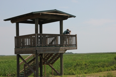
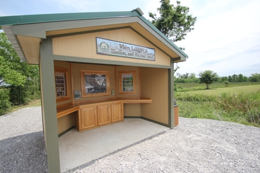
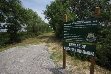
There is a 2-mile White Lake Birding and Nature Trail Map (PDF) on the north side of White Lake Wetlands Conservation Area. The trail is open to the public year-round, from sunrise to sunset daily. Visitor parking spaces for trail access are located at the entrance to White Lake, located 7.4 miles south of Gueydan at the south end of Hwy 91. The trail area includes a covered pavilion with tables, two educational kiosks with information on the trail and species in and around the area, and an observation tower (located at the southeast corner of the trail).
When using the trail, remember:
- The wetlands within and around the area provide habitat for reptiles, including alligators and snakes. Be aware of your surroundings and use caution if you encounter a reptile.
- Please keep small children close at hand and under supervision.
- This is a subtropical environment and can be very hot and humid, especially in the summer. Bring water, insect repellent, sunscreen, and proper clothing.
- Do not feed any wildlife that you encounter.
Trail Rules
- Pedestrians only - no vehicles, ATVs, bicycles, or horses.
- No pets.
- No loud music.
- No littering.
- No weapons or alcoholic beverages.
- Open flames are not permitted.
- Removal of vegetation is not permitted.
Address
15728 LA-91
Gueydan, LA 70542
Directions
- From Lake Charles, take I-10 east to the Jennings exit. Take Hwy 26 south; this will eventually turn into Hwy 14. Continue on Hwy 14 east to Gueydan. Take a right onto Hwy 91 and continue south for 7 miles. When the paved road becomes limestone, continue straight for approximately 200 yards and the elevated office building is on the left.
- From Baton Rouge, take I-10 west to the Estherwood exit, Hwy 91 south, which leads to Gueydan. At the stop sign at the intersection of Hwy 91 and Hwy 14 in Gueydan, take a right and a quick left to stay on Hwy 91 south and continue 7 miles. When the paved road becomes limestone, continue straight for approximately 200 yards and the elevated office building is on the left.
- From Lafayette, take Hwy 167 (Johnston Street) south to Abbeville. Then take a right onto Hwy 14 west. Continue on Hwy 14 for approximately 20 miles and turn left on Hwy 711. Head south for 2 miles on Hwy 711 and then turn right on Hwy 3143. Head west on Hwy 3143 for 3 miles. Take a left at the Hwy 91 stop sign and continue south for 4 miles. When the paved road becomes limestone, continue straight for approximately 200 yards and the elevated office building is on the left.