 Official Louisiana State Websites use .la.gov
  Secure .gov websites use HTTPS
 Boundaries (Saltwater/Freshwater and State/Federal)
Saltwater/Freshwater Line
Louisiana's saltwater/freshwater line extends easterly from the Texas state line all the way to the Mississippi state line. Areas north of this line are freshwater. Areas south of this line are saltwater, including Lakes Maurepas, Pontchartrain, and St. Catherine, Chef Menteur Pass (except a 7/10-mile section from Bayou Sauvage south to the Intracoastal Waterway), the Rigolets, Unknown Pass, Pass Manchac, the Intracoastal Waterway, and the portion of the Calcasieu Ship Channel from the Intracoastal Waterway south to the Gulf of America.
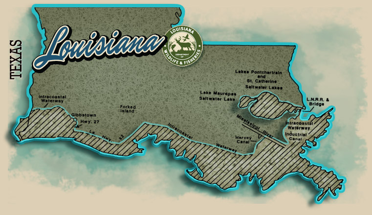
The line runs from the Intracoastal Waterway from the Texas-Louisiana boundary to its junction with Louisiana Highway 27 at Gibbstown, south to Louisiana Highway 82, east to its junction with the Intracoastal Waterway from Forked Island to Bayou Barataria to the Harvey Canal, the Harvey Canal to the Mississippi River, the Mississippi River to the Industrial Canal, the Industrial Canal to the Intracoastal Waterway, the Intracoastal Waterway to the Rigolets in Orleans Parish to the Louisville & Nashville Railroad Bridge, and the Louisville & Nashville Railroad right-of way from the Orleans Parish line to the Mississippi state line.
If you're fishing and/or possessing saltwater fish, you must have an LDWF Saltwater Fishing License in addition to an LDWF Basic Fishing License. Louisiana has many areas where you can catch fresh and saltwater species side by side. Instead of trying to determine exactly where the saltwater line is, the best practice is to purchase the additional LDWF Saltwater Fishing License if you’re fishing anywhere in south Louisiana and plan to catch any saltwater species.
State/Federal Waters Boundary
Generally, Louisiana state waters extend 3 nautical miles from the nearest land; federal waters extend from where the Louisiana gulfward boundary ends to 200 nautical miles seaward into the Gulf of America. However, for reef fish fishery management, Louisiana waters extend to 9 nautical miles. Fishermen should stay informed of the state/federal boundary as future congressional actions may affect the current boundary demarcation as it applies to reef fish species. If a future congressional action modifies the state/federal jurisdictional boundary, it will not impact the type of fishing gear reef fish fishermen may use.
LDWF, the Louisiana Wildlife and Fisheries Commission, and the Louisiana Legislature manage fisheries in state waters; the Gulf of America Fishery Management Council and the National
Oceanic and Atmospheric Administration‘s National Marine Fisheries Service (NOAA Fisheries) manage fisheries in federal waters, also known as the exclusive economic zone (EEZ). Federal fishing regulations are not always the same as state fishing regulations. To make sure that you are compliant with federal regulations, contact the Gulf Council at 888-833-1844 or gulfcouncil@gulfcouncil.org or visit the Gulf of America Fishery Management Council.
To easily tell if you're in state or federal waters, pull up to the nearest platform. Platforms in state waters have a placard with a state lease number. Platforms in federal waters are designated with an OCS number. You can also estimate your position by using a block map. The platform will be designated with an area and block number. For example, if you see ST-128 X, OCS 00498, you're in federal waters at South Timbalier 128 platform X.